

Leh: Following the tragic events of June 15, many Indians heard of the Galwan River Valley in Eastern Ladakh for the first time as the site of the deadliest clash between Indian soldiers and the Chinese People’s Liberation Army (PLA) since 1975.
According to reports, 20 Indian soldiers, including a Colonel, were killed and several others grievously injured. The Galwan Valley area, which lies east of the Siachen Glacier, offers the only direct access point to Aksai Chin. The Galwan River Valley was also the site of clashes in the Indo-China War of 1962.
The Valley itself derives its name from the river Galwan, which originates in the Karakoram range through Aksai Chin and Eastern Ladakh to join the river Shyok, an important tributary of the Indus River. This river, and the Valley, holds significant strategic importance for both nations, but particularly India.
The current standoff on the border traces back to China’s objections over a bridge the Indian government is building across the Galwan Nullah (as it was first known).
The naming of a ravine
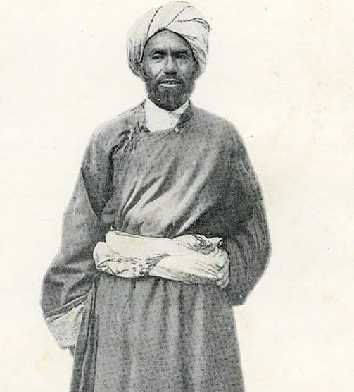
Interestingly, few Indians know Ghulam Rassul Galwan, a remarkable Ladakhi traveller and explorer, whose name the river has.
Through his remarkable autobiography, titled ‘Servant of the Sahibs’, he described his expeditions through the high Himalayas into Tibet and Yarkand (now situated in present-day Uyghur Autonomous Region of Xinjiang, China), and through the Pamir Mountains into Afghanistan, the Karakoram range and other parts of Central Asia. Galwan assisted many well known European explorers towards the end of the 19th century and into the early 1920s.
Galwan traversed these parts during a period in history known as ‘The Great Game’ when both the Russian and British Empire jostled for strategic supremacy over Afghanistan and neighbouring territories in Central and South Asia.
It was indeed a fascinating moment in history.
Galwan lived a remarkable life. It included accompanying the likes of Major HH Godwin-Austen, the English geologist responsible for measuring the height of K2 (the world’s second-highest peak) in 1887. He also travelled alongside Sir Francis Younghusband, the British empire-builder, spymaster and army officer responsible for the signing of the 1904 Anglo-Tibetan Treaty, for more than six years (1890-96) during different expeditions.
The name ‘Galwan Nullah’, or Galwan River as we know it today, came during the 1892 mission to the Pamir Mountains with Charles Murray, the 7th Earl of Dunmore and a Lieutenant-Colonel in the British Army at the time.
While the purpose of that trip remains a minor mystery, what is known is that on the journey back, the caravan strayed away from traditional routes in Aksai Chin because of bad weather. Then there came a moment when a wall of mountains and steep gorges trapped them.
Unable to find a way out, a 14-year-old Galwan stepped up to find a possible way out of this maze. Much to the amazement of Murray’s team, the young teen used all his instincts and knowledge of treacherous terrain to find a relatively easier route through a ravine which kept the expedition going without much trouble.
Historian Abdul Ghani Sheikh writes that Murray was so pleased with Galwan’s efforts that he decided to name the newfound passage through the ravine as the ‘Galwan Nullah’ and the Valley as ‘Galwan Valley’.
This was a significant development because colonising Westerners would usually name major geographical features after themselves, no matter what the locals or common history called the features.
Historical context
Traditionally, there has been little commerce in Ladakh itself. But for centuries carpets, creams, tea, salt, grain, pashmina or cashmere wool, silk yarn, cotton and indigo traversed through these parts in caravans, via the fabled Silk Route. This trade had always attracted merchants from Yarkand, Tibet, Kashmir, Central Asia and even Punjab.
But by the middle of the 19th century, politics brought armies from Jammu and the British as well. Ladakh’s royal Namgyal dynasty had been ousted from power by the troops of Jammu’s ruler, Gulab Singh. Gulan Singh sold his ambitions to the British as a ‘stable northern frontier’, and thus the State of Jammu and Kashmir was created in 1846.
Ladakh had now become part of the buffer zone between British India and the Chinese and Russian empires. After that, a steady stream of British and Dogra surveyors travelled around Ladakh, measuring the land and mapping it, their movement made possible through the labour of Ladakhis, their sustenance provided by villagers along their routes, according to this academic paper by Dr Martijn van Beek, a Ladakh scholar of Aarhus University, Denmark. It was in such times that Galwan was born.
